
Learn with Enrico and Nestor why taking your GIS mobile with Next saves your company money.

Next is a powerful field-based information management system that collects and combines a wide range of data types from multiple sources. What sets Next apart from conventional mobile GIS solutions is that data is always accessible, even when it is offline.

We believe that eliminating paper is key to improving productivity and job satisfaction because field-based users now have greater accessibility to all the right information to get the job done. Also, going paperless reduces your organisation’s carbon footprint and is good for the environment too! Use Next to experience the benefits of paperless and edit networks directly in the field, visualise underground networks using augmented reality, and much more.

Next is specially designed to work with Android, the world’s most popular mobile platform. It leverages the data on your device without compromising performance, security or useability. Even the most complex searches over large data volumes yield instant results. No waiting, no fuss, just productivity!
Our innovative mobile solution encourages better collaboration between field-based operators and back-office colleagues. The app effortlessly distributes GIS data and documents to operators. Several features allow assessment of network status, perform data collection, and send feedback from the field. Real-time updates keep back-office better informed and improve decision-making.
Next is incredibly versatile and perfect for:


Next is designed for seamless integration with your existing IT systems making it ideal for:
The following illustration shows how Arcoda Next seamlessly integrates into existing core systems without the need to make significant changes. This has the added benefit of improved information flows between the operators in the field and back-office teams.

Easily synchronise maps, data, and documentation on the operator’s device with the application server database. This combined with focused distribution ensures that operators only receive the data they need to get the job done right first time, every time. Once the data has been downloaded, no further connection with back-office is required!
Improve network management with timely and accurate updates from the field and encourage better collaboration between field operatives and back-office teams.
Use Next to rapidly identify assets of interest on the map and then save time travelling to them. Next automatically passes the asset location to Google Maps or other favourite navigator, allowing users to follow step-by-step navigation to asset destination.
Next makes it easy to perform rapid network edits by drawing new assets directly on the mobile device. Now field-users can suggest network edits at source and use built-in GPS or manually position elements on the map. These updates can then be quickly sent to back-office for validation.
Whether you use built-in GPS, external high precision GPS or laser measuring instruments, you can rely on Next to deliver the accuracy you need to get the job done.
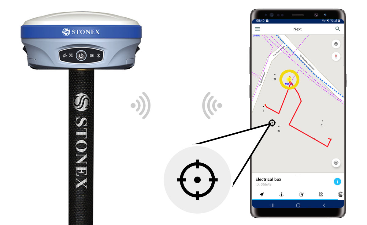
With a simple connection via Bluetooth from mobile device to precision GPS hardware, Next delivers unparalleled accuracy when positioning network objects on a map.
Next transforms the way you work. Now you can experience all the benefits of augmented reality on your mobile device without additional hardware. Go beyond GIS and leverage technology that allows digital information to be overlaid on real physical environments. Next provides easy and immediate data access to simplify daily tasks, inspections, network object identification, and more.
The applications are developed on Arcoda AST (Arcoda Spatial Target), a development platform dedicated to the implementation of advanced functions for the use of augmented reality techniques within network operators.
AR-Onsite simplifies inspection operations as it helps users visualise networks in augmented reality. Using the information stored within GIS layers, AR-Onsite virtually positions assets in the user's real-world view. For example, underground pipework will appear directly at ground level. This enables the operator to conduct an immediate evaluation of required interventions.
Next’s powerful AR-Inventory feature supports meter-room verifications. AR-Inventory is used to capture the presence of meters located in a meter-room and compare with existing records making it an ideal asset auditing tool. This presents a compelling alternative to traditional methods when speeding up company database maintenance.
AR-Inventory is secure and eliminates the pitfalls of publically displaying asset data. Instead this information can be encoded into customised barcodes or QR codes that can be easily framed with a smartphone camera. When a barcode or QR code is read, information is instantaneously superimposed over the meter in augmented reality. This information would include, amongst others, customer data that can be used to generate an automatic report that is sent via Next to back-office for validation.
Next uses the AR-Identifier to radically transform the way field-users view network assets. Now real-time information is superimposed on the asset itself rather than sifting through a mobile device to find it. Just looking at an asset will reveal invaluable real-time data even in enclosed environments with no internet connection. This means that users can view status checks, interventions performed, installed power, user information, the possibilities are endless.
AR-Inview is perfect for assessing the status of assets contained within cabins or other enclosed environments. With Next, looking directly at the asset will reveal superimposed digital labels for each asset in the enclosed space. The user need only to pan their smartphone around the space to view, edit or create new information labels above respective assets. With Next paper documentation is eliminated, intervention times significantly reduced as asset data updates occur in real time. Also, users are better engaged as Next supports learning processes, especially with regards to the identification of a multitude of assets.