Enhanced quality vehicle route tracking. Points along the route are sampled at between 2 and 60 second intervals based on the route geometry

Monitors the work activities of the personnel and of the machines installed on the vehicles. Provides telemetry readings of the on board measuring sensors and instruments.

Integrates with the company procedures, in synergy with the local business and work force management systems.

You manage digital tachographs and driver cards remotely. It's quick and easy! Read more
Arcoda Sat is the ideal solution for effortlessly monitoring vehicle fleets. The platform is a window on driver activity on the ground providing a continuously updated picture on vehicle location, based on the use of Google Maps, OpenStreetMap and other map applications.
Fields of application for Arcoda Mobile GIS


")


 that delimits the headquarter")
")
Arcoda Sat, besides geolocating vehicle fleets, also provides other advanced functions that make it a unique and innovative product. It is, in fact, an all-round platform for GPS fleet tracking, which also remotely monitors activities by means of onboard tools and devices. Arcoda Sat offers specific functions for checking both in-house and outsourced activities.

Enhanced quality vehicle route tracking! The figure belows summarizes how this platform works. Vehicles are equipped with a tiny satellite tracking device. It collects the map coordinates and interfaces with the sensors of the vehicle. This device gathers location and telemetry data and forwards them to the Arcoda server. Points along the route are sampled according to specific smart algorythms.

Thanks to a set of sophisticated algorithms, the system can interpret satellite data to clearly display the journey routes, vehicle device activity, stops and prolonged stops with engine on or off. It analyses the data and features various dashboards for controlling the fleet use indicators, storing the data for up to a year.
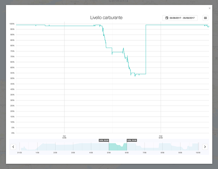
The Arcoda Sat units installed on the vehicles are directly connected to the vehicle’s CAN BUS to monitor fuel consumption and fuel tank levels for effectively controlling costs.
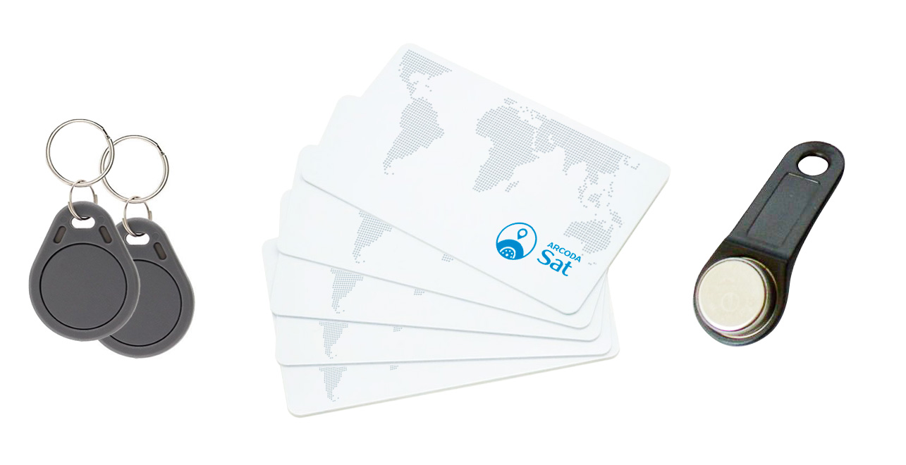
For safety purposes, the vehicle units provide a driver recognition feature and badge-based monitoring (NFC, RFID 125 MHz, iButton), for the centralised management of driver authorisations.
Arcoda Sat features a GIS (Geographic Information System) module for displaying the trackings in relation to the corporate infrastructure (clients, offices, networks, delivery points) and displaying other mapping backgrounds in addition to those of Google Maps® such as, for example land registry maps, orthophotos, CTN, Open Street Map.
The system also offers a deadline reminder function as regards insurance premiums, ownership tax payments, scheduled vehicle inspections and maintenance, based on dates, kilometres travelled or hours of use. The function can send reminders by email to one or more addresses.
The GPS location units may be interfaced with the digital tachograph for the automatic remote downloading and storage of the vehicle and driver data, in accordance with the law. The data is processed to determine any violations and to automatically generate a warning letter.
Arcoda Sat also features tools for generating notices and alerts. Notices can be sent in conjunction with circumstances involving a degree of interaction of the vehicles with certain specific places of interest (entries, exits) or in certain so-called “protection” time-slots defined by the user. The circumstances and events that trigger an alert may be managed by means of text messages, emails or through the support of a central control room.
Arcoda Sat creates detailed reports that may be displayed in the portal or exported in the most widely used formats (pdf, xls, csv, txt, rtf). Reports on distance travelled, speed, hours of vehicle use, fuel consumption, work sessions, entries or exits into or from special areas, as defined by the user directly on the map, driver ID, tachograph, battery charge level, refrigerator compartment temperature, etc.. The reports and graphs may be tailored to suit the user’s needs.
Discover all the advantages offered by a fleet location system that can be integrated with the other Arcoda suite modules. You may add to the tracking environment your GIS, the georeferenced management of your work orders, the location of your assets on the ground, the tracking of vehicle work activities and time stamping directly on board the vehicle!
Se vuoi approfondire maggiormente le potenzialità della nostra soluzione per la localizzazione flotte, visita il sito dedicato!
www.arcodasat.it No, preferisco rimanere su questo sito